10 Of The Longest Highways In The World, Ranked By Length
Humanity has built roads from Mesopotamia to the present day, some connecting cities, others spanning entire countries and continents. Following some of the world's longest highways from end to end gives travelers the chance to witness the world gradually changing before their very eyes. These highways roll on for thousands of miles and stretch through deserts, mountain ranges, and jungles, making them much more than just corridors of transportation. They are epic adventures and that test the mental and physical endurance of bikers, truckers, cyclists, and anyone else determined enough to traverse them.
These roads pass through numerous border crossings and time zones, and the extreme environments some of them navigate may not be for everyone. Road conditions can vary wildly, especially those of less-developed nations. The smooth asphalt of North America or Western Europe can soon give way to lengthy and poorly maintained sections that are already difficult enough due to extreme weather and challenging terrain.
One lengthy road we decided not to include due to its poor condition is the Tripoli to Cape Town Highway (TAH 3). With its large missing sections and poorly maintained segments, we deemed it unworthy despite its impressive 6,716-mile length. Other epic highways around the world we have decided against include the Asian Highway Network (AH). Environmental and political issues have hindered the realization of the AH1, and a missing link between Nepal and India on the AH2 persists. Additionally, substandard road conditions in several sections make the AH5 a questionable inclusion, while the AH6 remains incomplete, particularly on the North Korea/Russia section.
The Golden Quadrilateral, India: 3,633 miles
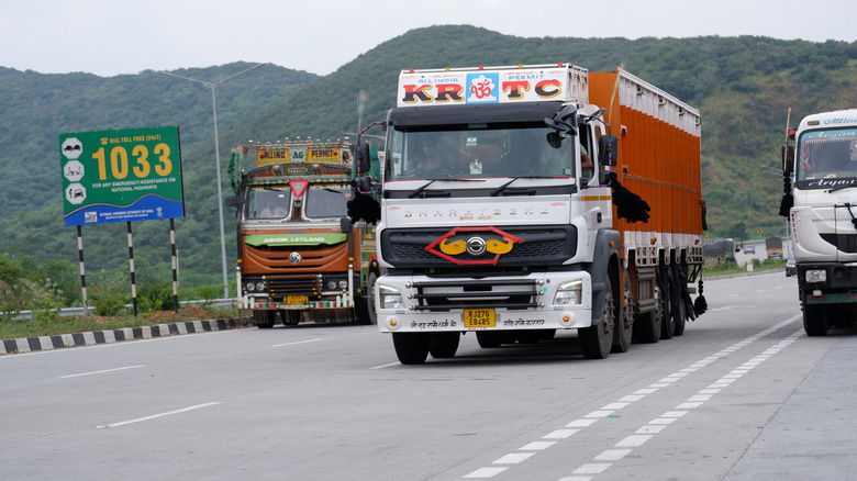
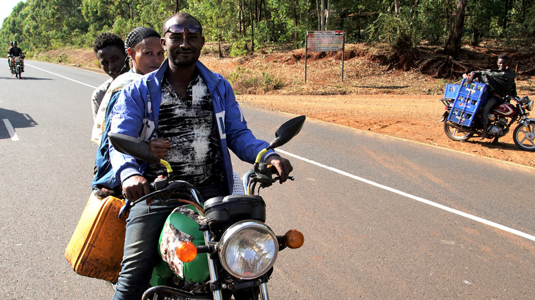
Anyone who has dreamed of buying a Royal Enfield and touring India, where the classic British motorcycle is now manufactured, should consider the Golden Quadrilateral. This epic loop is a biker's paradise and encircles the heartland of this fascinating country. It connects India's four major metro cities, Delhi, Mumbai, Chennai, and Kolkata, and covers 12 states, a union territory, and about 3,600 miles.The highway links key industrial and agricultural regions and, upon completion, marked the realization of one of India's most ambitious infrastructure efforts. It significantly improved freight movement and intercity travel and is also the inspiration behind the still-under-development Diamond Quadrilateral high-speed rail project.
Offering riders an intense yet kaleidoscopic experience across India's major urban and rural corridors, traversing this highway takes in stunning coastal regions, arid plains, chaotic cities, and underdeveloped countryside. The condition of the highway is somewhat inconsistent, but much of it is smooth, rolling asphalt, which is an exception compared to other highways in the country. However, some sections are limited in amenities, with fuel gaps one particular challenge riders need to overcome at times. Extreme weather challenges are also common and traffic can get intense as you near the cities, but the cultural diversity that arrives with every state line crossing reaps the rewards that are so desirable to adventurous travelers.
Trans-Canada Highway, Canada: 4,860 miles
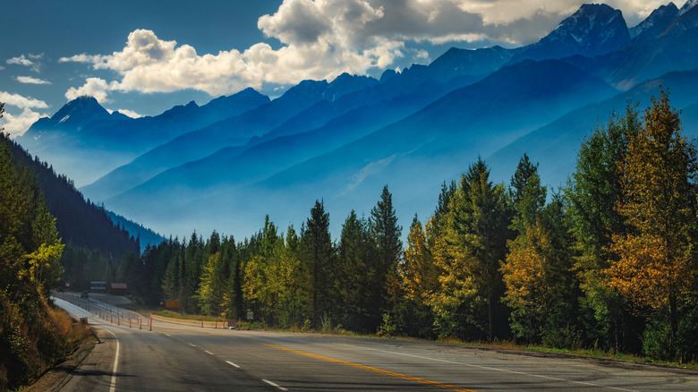
The Trans-Canada Highway is a magnificent feat of engineering. It stretches across the entire breadth of the country, with work beginning on it back in 1949. However, the entire route wasn't completed until 1971. Traveling it takes you from Pacific shores to Atlantic waves on a massive 4,860-mile journey through incredible Canadian landscapes. Its path includes ocean crossings by ferry to Vancouver Island and Newfoundland, plus a causeway linking Cape Breton to mainland Nova Scotia.
The journey takes in the mighty Fraser River and the striking geological sites of Hell's Gate Canyon, as well as the majestic peaks of the Rockies and historic towns like Hope and Cache Creek. Then there's Revelstoke's alpine scenery and the impressive sight of Yoho National Park with its turquoise lakes and powerful waterfalls. This route is ideal for nature lovers and adventure seekers, but you can also take alternative branches onto designated secondary routes that are still officially part of the broader Trans-Canada Highway system. They cut through northern Alberta and Saskatchewan and extend on to Prince Rupert on BC's coast. Another route connects New Brunswick to Prince Edward Island via the impressive Confederation Bridge.
You can travel most of the Trans-Canada Highway by bicycle. However, it requires careful planning, as some stretches prohibit bikes due to high-speed traffic. The highway also has narrow shoulders and even wildlife hazards like bears and wolves in northern Ontario, making the alternative routes preferable for safer cycling.
European Route E60, multiple countries: 5,100 miles
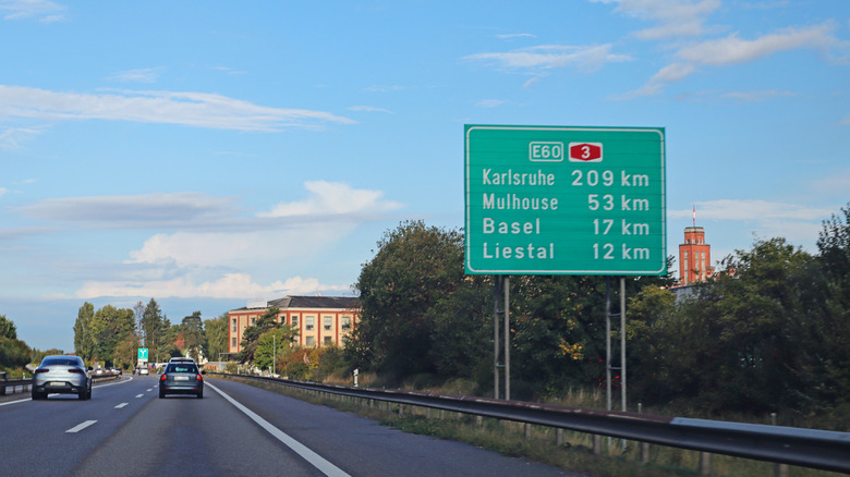
The E60 highway stretches from the Atlantic harbors of Brest in the west of France some 5,100 milesto Central Asia in the east. It's a vital thoroughfare that links diverse regions and cultures, and driving it will take you through mountainscapes, deserts, and ancient cities before reaching Kyrgyzstan's frontier with China. For truck drivers, the E60 serves as a modern Silk Road, creating a lifeline for economic exchange. For travelers, the shifting landscapes, traditions, and cultures make for a fascinating journey and, potentially, a transformative experience.
Riding from west to east, the road screams modern engineering. As you travel eastward, the challenges of such an ambitious transcontinental route reveal themselves. In parts of Romania, for example, the well-maintained asphalt transforms into a gauntlet of jarring potholes. Uneven surfaces can test your vehicle and, indeed, your patience. Additionally, everything from freight trucks to horse-drawn carts plies this road, which does create a unique traffic environment. But the meeting of steel behemoths with rustic transportation can also cause dangers, and drivers need to exercise caution and quickly adapt.
In Georgia, challenges continue to plague this vital corridor. However, things are better than in Romania thanks to a $75 million investment by the World Bank that ensured trucks could transport more efficiently and safely along the route, which cemented the country's position as a crucial transport hub between Asia and Europe.
European Route E40, multiple countries: 5,405 miles

The E40 in Europe is the result of post-WWII UN planning. It was meant to help heal a continent left in ruins by reconnecting nations that were torn apart by the conflict. It follows the pathways of the Silk Road, where traders once carried exotic goods between East and West, but its length is somewhat debated. Most sources will tell you that the E40 is the longest highway in Europe. However, many of those sources also tell you it is 4,791 miles long, making it shorter than the E60. Some sources state it to be around 5,400 miles, which does verify its claim as Europe's lengthiest.
Regardless of what you believe, it is still one long road. It connects France in Western Europe with Kazakhstan in Central Asia, traversing 10 countries in its journey through the heart of the continent. From Calais, it heads east to the EU capital of Brussels before continuing onward to Germany and Poland. After that, you reach Ukraine. In sections near Kyiv and Kharkiv, once bustling transit corridors are now battlegrounds that mock the peace and prosperity the road was initially built for. The E40 continues on its way to Russia and the central Asian countries before terminating in Ridder, Kazakhstan, near the border of China.
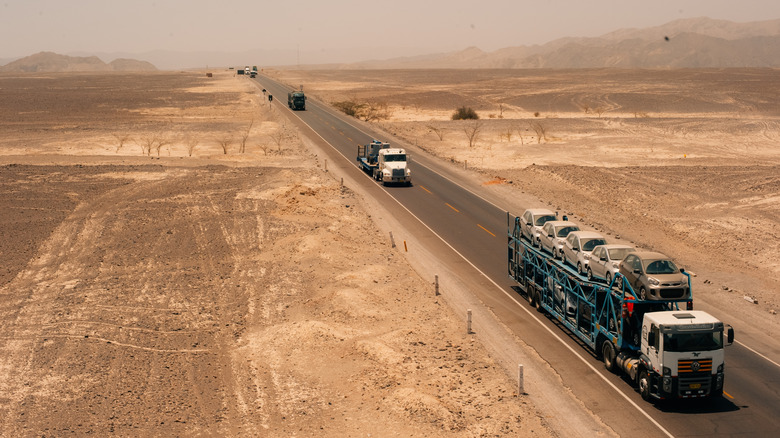
Cairo–Dakar Highway, multiple countries: 5,366 miles
The second-longest road in Africa is the Cairo-Dakar Highway, also known as the Trans-African Highway 1 (TAH 1), which spans 5,366 milesfrom the Egyptian capital to Dakar, Senegal, in West Africa. It follows the north African coast along the Mediterranean Sea and Atlantic Ocean and passes through eight countries — Libya, Tunisia, Algeria, Morocco, Western Sahara, and Mauritania — sandwiched between Egypt and Senegal. The section linking Tunisia to Libya was completed as recently as 2020, which marked the final piece of the puzzle needed to complete this transcontinental route. In Dakar, it connects with the Dakar–Lagos Highway (TAH 7) to form a broader corridor around West Africa's coast and into the Sahara.
However, while the road is physically in place, it's impossible to traverse its entirety due to the closure of the Algeria-Morocco border since 1994. Additionally, road conditions range from smooth asphalt to uneven or isolated segments that will call upon any driver's adaptability, including a key section near the Western Sahara–Mauritania border that remains a desert track. You may prefer a unique adventure motorcycle for parts of this highway, but just riding the sections that are possible will take you through ancient landmarks like the pyramids before blending in Roman ruins and coastal cities with landscapes that are remote, rugged, and stunning.
National Highway 219, China: 6,214 miles
China may have some of the fastest trains on the planet, but that doesn't mean epic road travel is a thing of the past. Winding for 6,214 miles through some of the country's most dramatic scenery, National Highway 219 is the longest in China. It begins in Kom-Kanas in the northwestern province of Xinjiang and takes the hardiest of adventurers through incredible landscapes. It terminates in the south of the country next to the Vietnamese border in the tiny (by Chinese standards) town of Dongxing in Guang Xi province. It crosses remote, mountainous, and often disputed regions and helps China to secure its borders in sensitive areas like Aksai Chin and Tibet by allowing rapid military access and surveillance.
A major resurfacing project took place between 2010 and 2012 and development is ongoing, making it more accessible for travelers to ride. However, National Highway 219 is still a test of endurance and nerve. It's known as the "Sky Road" because it traverses barren, high-altitude terrain with oxygen-thin air, freezing temperatures, and gale-force winds. You can go hundreds of kilometers without access to food, fuel, or shelter, and the isolation is not for everyone. Travelers will also face military checkpoints, particularly on the Xinjiang to Tibet stretch, and altitude sickness is a very real problem. If you are the determined type, overcoming these challenges offers raw, unfiltered access to some seriously dramatic landscapes. The beauty and remoteness do attract only the most determined, but for those willing to embrace the hardships, the rewards are unmatched.
Cairo–Cape Town Highway, multiple countries: 6,355 miles
Spanning 6,355 miles across nine countries from northern Africa to South Africa, the Cairo–Cape Town Highway is the longest fully traversable highway in Africa. Beginning in Egypt, the road stretches across the continent through Sudan, South Sudan, Ethiopia, Kenya, Tanzania, Zambia, and Botswana before finally terminating in Cape Town, South Africa. The highway is also known as Trans-African Highway 4 (TAH 4) and is currently being developed under the Trans-African Highway network by the United Nations Economic Commission for Africa (UNECA).
However, while largely complete, conflict disrupts some sections, particularly in South Sudan. This makes driving the entire route a challenge. Determined travelers who do make the effort are treated to a rugged journey across vast African landscapes and cultures. The journey can take months, but it slowly reveals the continent's diversity from the ancient waters of the Nile and the dry expanse of the Sahara to Maasai villages and remote highland farms. The roads can be rough with potholes, waterlogging, and even blockades of buffalo, and facilities are basic for long stretches. However, you simply can't beat wild camping under fiery African skies, and the dramatic scenery and cultural depth this route delivers make it one of our planet's greatest overland journeys.
Trans-Siberian Highway, Russia: 6,800 miles

The Trans-Siberian Railway may be one of the longest train lines in the world, but did you know there's a road that runs alongside it? That road is the Trans-Siberian Highway. It's the third longest on Earth at a staggering 6,800 miles in length and is an epic journey cutting through the wild heart of Russia. Starting in Moscow, it snakes and twists its way to Vladivostok on the other side of the enormous country, terminating just east of the Chinese and North Korean borders.
Once upon a time, the notorious 400-mile Zilov Gap in central Siberia was almost impassable and forced most travelers to load their bikes onto the train. However, the road is now fully sealed, giving adventurers complete passage across the vast Russian landscape. This makes things much easier for bikers, drivers, and cyclists, but choosing the right time to go is still essential. Summer delivers comfortable temperatures, but winter brings endless frozen landscapes and frigid temperatures that can severely hamper journeys.
The trip takes you across 23 distinct regions and seven time zones. It passes through the historic charm of Irkutsk and the natural wonder of Lake Baikal, the world's deepest freshwater lake, as well as seemingly endless taiga forest and pristine wilderness where you may not see another vehicle for days. There's even a 1,000-mile stretch between Chita and Blagoveshchensk that's devoid of a single city, so you had better book any roadside motels ahead, especially when traveling in the dead of winter.
Highway 1, Australia: 9,000 miles
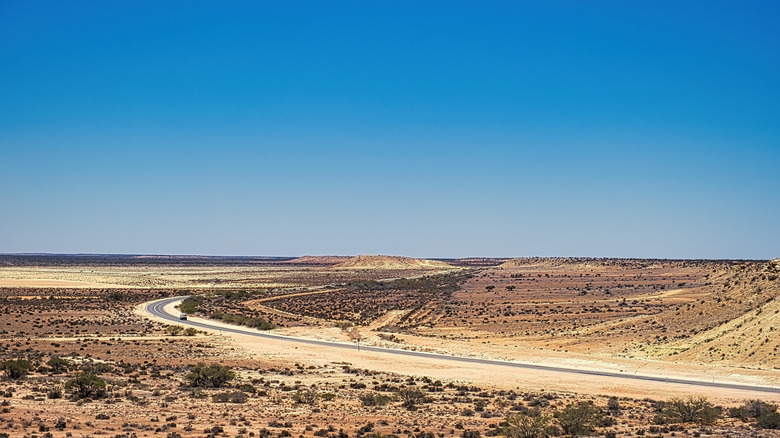
Highway 1 in Australia, aka the "Big Lap," is the world's longest national highway and the second longest highway on the planet. It's a mind-boggling 9,000 miles long and completely encircles the country's mainland. Like most of the highways on this list, it's not a single road. It's an interconnected system that links every state capital in Australia. It hugs the spectacular coastline for most of its length, and a journey around it offers insights into the diverse landscapes and ecosystems of this fascinating country.
Much of Highway 1 follows historically significant routes established during the times of Australia's early European settlement. It also weaves through culturally rich Indigenous areas, providing travelers with opportunities to connect with one of the world's oldest continuous cultures. The journey covers multiple climate zones, from the tropical heat of the north to the more temperate conditions of the south, at least if you ride in winter — otherwise, the South is every bit as hot!
Starting in the harbor city of Sydney, travelers, bikers, RVers, and whatever-else-ers can experience everything Australia has to offer, from the golden beaches of Queensland to the tropical rainforests of the north. You can even take in the eucalyptus forests of Tasmania. Yep, that's right. To be able to say you truly rode the Big Lap, you need to take a ferry from Melbourne to Tasmania, where you will find a continuation of Highway 1 that links with the island's capital city, Hobart.
Pan-American Highway, multiple countries: 19,000 miles
The Pan-American Highway is a staggering ribbon of asphalt and concrete that stretches 19,000 miles from Alaska all the way to the southern tip of Argentina. The idea for this road first came about in 1923, with the U.S. and Mexico being the major players in its development. Across the Americas, other countries soon joined in to piece together the world's longest continuous road network. Well, that's not exactly true. There is a missing piece in this puzzle called the Darien Gap. This unconquered 100 km expanse sits between Panama and Colombia and is the result of impenetrable rainforests and treacherous marshlands. Travelers hoping to traverse the entire road will have to hop on a boat or a plane to bypass this wild stretch.
However, riding the Pan-American Highway will take you on a grand adventure through 14 countries and across two continents. You'll see everything from the snow-capped peaks of Alaska through tropical jungles, arid desert, and stunning Pacific coastline before reaching the otherworldly landscapes of Patagonia and Ushuaia, the southernmost town in the world. It's a challenging journey, especially if you're on a motorbike. Road conditions vary wildly, with sealed highways suddenly giving way to rugged dirt paths, while the weather can also fluctuate drastically. Careful preparation is required, but it is one of the world's most epic adventures and should absolutely be added to any road trip bucket list.