The 11 Longest Highways In The U.S., Ranked
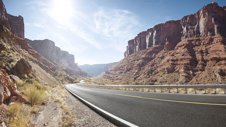
The United States is a vast and diverse country, spanning dense forests, freezing mountain ranges, and sprawling, arid deserts. To cover a massive landmass of 3.81 million square miles, the country has an extensive network of highways and freeways to connect cities, towns, and even rural areas, making epic grand touring routes.
What's the difference between highways and freeways? The terms may be used interchangeably across the U.S., but they are different according to the Department of Transportation. One of the key distinctions is that freeways generally have higher speed limits compared to highways. Additionally, highways often have traffic signals, while freeways do not. The creation of the first U.S. highway system dates back to June 29, 1956, when President Dwight D. Eisenhower signed the Federal-Aid Highway Act of 1956 and chose Missouri as the first state to receive interstate highway funding. Since then, the U.S. has developed a sweeping road network that is home to some of the longest highways in the world.
U.S. Route 20 (3,365 miles)
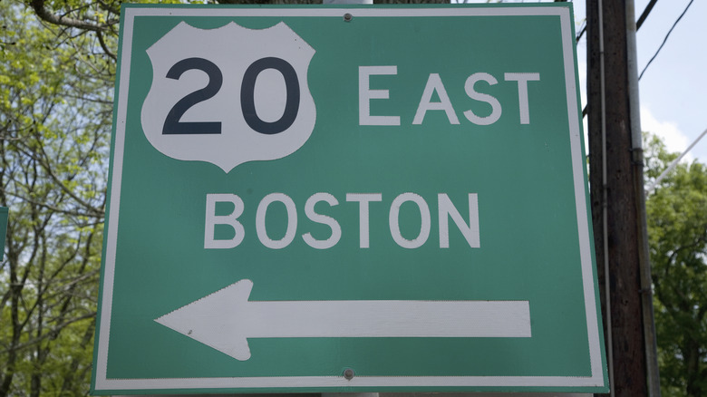
U.S. Route 20 is the country's longest road, covering 3,365 miles from Boston, Massachusetts to Newport, Oregon. This highway passes through 12 states, including Idaho, Montana, Wyoming, Nebraska, Iowa, Illinois, Indiana, Ohio, Pennsylvania, and New York. Wyoming has the longest stretch of Route 20, spanning 525 miles of its total 3,365 miles.
This highway takes travelers through the rolling Midwest farmlands, towering Rocky Mountain peaks, and dense forests of the Pacific Northwest. A major highlight along U.S. Route 20 is Yellowstone National Park, the world's first national park. The highway covers roughly 92 miles of Yellowstone National Park, entering through the park's eastern entrance near Cody, Wyoming, and exiting through the western entrance at West Yellowstone, Montana. U.S. Route 20 also passes through many old-fashioned small towns such as Sharon Springs, Richfield Springs, Cazenovia, and Skaneateles, making it a perfect stretch of the Northeast for a comfortable motorcycle journey.
U.S. Route 6 (3,205 miles)
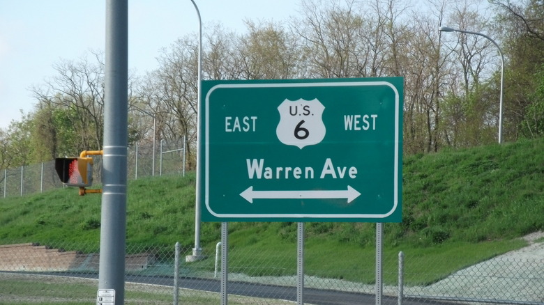
Established in 1926, U.S. Route 6 was once the longest highway in America, spanning termini in New England and California. However, in 1964, authorities truncated the route by 250 miles and, technically, ceded the crown to Route 20. Still, Route 6 is continentally large, spanning 3,205 miles from Provincetown, Massachusetts, to Bishop, California. U.S. Route 6 takes you through 14 states and is also known as the "Grand Army of the Republic Highway," honoring American Civil War Veterans.
Traveling along U.S. Route 6 offers diverse terrains, landscapes, and cultures. It takes travelers from the coastal villages of New England to the mountains of Sierra Nevada, passing through some of the remotest parts of America. Notable attractions along this route include the beaches of Cape Cod, striking views of Denver, and scenic views of California's Owens Valley. One of the most iconic stops on U.S. Route 6 is the Pilgrim Monument in Provincetown, Massachusetts, built between 1907 and 1910 to commemorate the landfall of the Pilgrims in 1620.
U.S. Route 30 (3,073 miles)
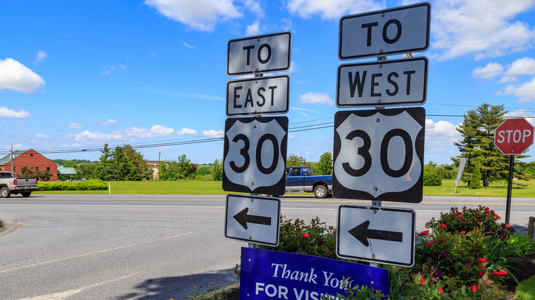
Stretching 3,073 miles, U.S. Route 30 is home to the famous Lincoln Highway, the first road in America, built in 1913. Approximately 200 miles of the Lincoln Highway — originally stretching from New York City to San Francisco — now forms part of the U.S. Route 30, specifically in Pennsylvania. Today, the U.S. Route 30 is the fourth-longest highway in the United States, beginning in Atlantic City, New Jersey, and ending in Astoria, Oregon.
The number "0" in U.S. Route 30 signifies its status as a major coast-to-coast highway and a major east-west route. One important historical fact about U.S. Route 30 is that, unlike the now decommissioned U.S. Route 66, it remains the only active coast-to-coast highway that is an essential part of the U.S. Numbered Highway System. This highway passes through 11 states: Oregon, Idaho, Wyoming, Nebraska, Iowa, Illinois, Indiana, Ohio, Pennsylvania, West Virginia, and New Jersey.
Once you've prepared your car for adventure, you can take U.S. Route 30 through a diverse cross-section of America's landscapes and cultural history. Landmarks include the Flight 93 Memorial, the Giant Coffee Pot, and the 1806 Old Log Church.
Interstate 90 (3,020 miles)

Interstate 90 (I-90) is America's longest interstate highway, spanning 3,020 miles from Seattle, Washington to Boston, Massachusetts. It was built in 1927, a year after the now-decommissioned U.S. Route 66. A ride on this amazing route gives stunning views of the Pacific Northwest, the Great Plains, and the bustling cities of the Midwest. The I-90 crosses major cities of the U.S. such as Chicago, Cleveland, Buffalo, and Rochester.
Interstate 90 starts at Washington State Route 519 in Seattle, and ends at the eastern terminus at Massachusetts Route 1A near Logan International Airport in Boston. Interstate 90 was established by the Federal-Aid Highway Act of 1956 by replacing multiple other U.S. highways, and it was numbered in 1957.
Some of the iconic landmarks that riders can visit by taking a short detour off the I-90 include Chestnut Ridge Park in New York, Superman's birthplace in Ohio, Mount Rushmore, Devils Tower famous for appearing in Steven Spielberg's movie "Close Encounters," Badlands National Park, among others. Additionally, Interstate 90 also passes through three major mountain passes: Snoqualmie Pass, Lookout Pass, and Homestake Pass.
U.S. Route 50 (3,019 miles)
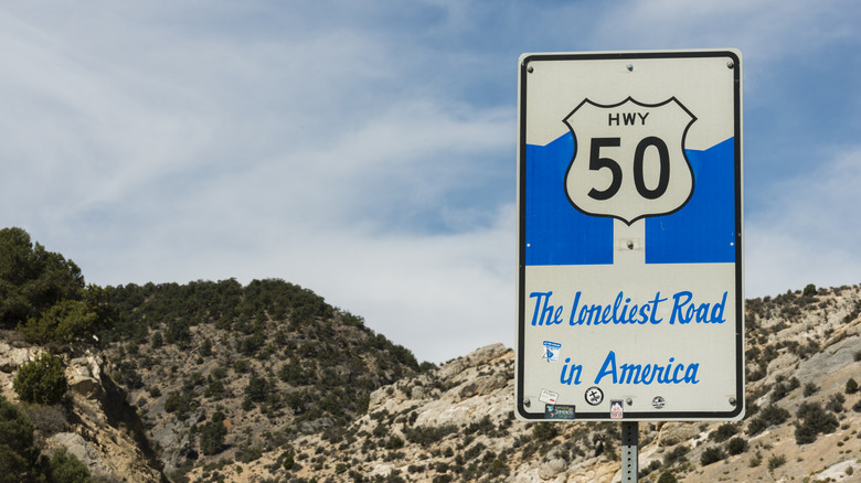
U.S. Route 50 is another of the longest highways in America, but its length is not what makes it famous. In 1986, Life Magazine dubbed it the "Loneliest Road in America" due to its remote stretches with few signs of civilization. U.S. Route 50 passes through some of the nation's harshest desert landscapes — a place where one would not want to be without water, food, camping gear, and other survival supplies.
Despite its isolation, U.S. Route 50 spans 12 states en route from Ocean City, Maryland to Sacramento, California. Due to its significance in American transportation history, Time Magazine once dedicated an entire issue to it, calling it the "Backbone of America."
Along the route, riders can enjoy some of the iconic stops such as South Lake Tahoe, which is one of the largest and deepest lakes in the U.S., the historic Wild West of Carson City, Great Basin National Park, Spencer Hot Springs, and more. It is a great route for any road tripper, especially with these game-changing car gadgets.
Interstate 80 (2,901 miles)
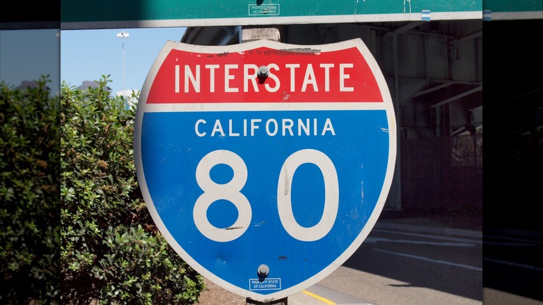
Interstate 80 (I-80) is a major transcontinental route stretching 2,901 miles from San Francisco, California, to Teaneck, New Jersey, just 10 miles outside of New York. This route offers a mix of urban and rural landscapes, with views of the bustling streets of Teaneck, which is a part of the New York Metropolitan Area along with the iconic cityscape of San Francisco. The highway runs along the iconic Lincoln Highway, America's first highway, and follows part of the Oregon Trail.
The I-80 passes through 11 states including California, Nevada, Utah, Wyoming, Nebraska, Iowa, Illinois, Indiana, Ohio, Pennsylvania, and New Jersey. Construction of the Interstate 80 began in 1956 and was completed in segments. Some parts of the highway, such as the stretch from Mitchellville to Des Moines, Iowa, are rumored to be haunted by a ghost-like figure appearing along the road. When passing through a spot near Fort Bridger, Wyoming, the ride is famously known as the "Highway to Heaven" because it creates an optical illusion that appears as if the road is reaching towards the sky.
In Wyoming, the I-80 reaches an elevation of around 8,640 feet above sea level at a point between Laramie and Cheyenne. Notable attractions along I-80 include the Golden Gate Bridge in San Francisco, Cuyahoga Valley National Park, Cleveland, Empire Mine State Historic Park, Sierra Nevada Mountains, Bear River State Park in Wyoming, and much more.
U.S. Route 60 (2,655 miles)
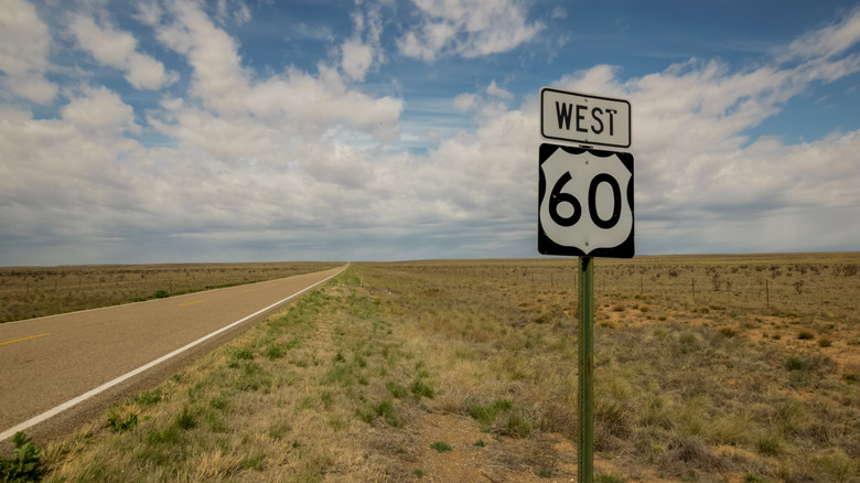
U.S. Route 60 is one of America's original highways, before the formation of the Interstate highway system. It stretches 2,655 miles from Virginia to Arizona. In addition to those two states, Route 60 passes through seven others including New Mexico, Texas, Oklahoma, Missouri, Illinois, Kentucky, and West Virginia.
Riders will experience a unique contrast, starting at the sun-drenched coasts of Virginia Beach and ending in the arid landscapes of Arizona. Interestingly, the now-decommissioned U.S. Route 66 was originally intended to be numbered U.S. Route 60. A crucial artery of transportation and trade, Route 60 was funded accordingly. A segment of the highway in Arizona is known as "The Million Dollar Highway" because its construction cost approximately $1 million.
In West Virginia, Route 60 is also known as Midland Trail National Scenic Byway, owing to its beautiful views and access to landmarks including Hawk's Nest State Park, New River Gorge Bridge, and Blenko Glass, which is one of the only operating glass factories in West Virginia.
Interstate 40 (2,559 miles)
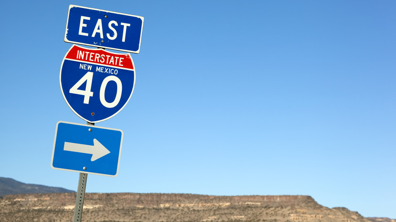
Interstate 40 (I-40) was established by the Federal-Aid Highway Act of 1956. Along with other highways including Interstate 55, 44, 15, and 10, Interstate 40 replaced a significant portion of the famous U.S. Route 66, which was eventually decommissioned in 1985. It officially received its designated number in 1957.
The I-40 passes through a variety of landscapes, crossing eight states: California, Arizona, New Mexico, Texas, Oklahoma, Arkansas, Tennessee, and North Carolina. The state of Tennessee has the longest stretch of I-40, spanning 455 miles. Interstate 40 is historically significant as an original trunk road and foundation of the Interstate Highway System.
It is often considered a preferred route for cross-country travelers, offering numerous attractions, including the Grand Canyon, Petrified Forest National Park, Hot Springs, Blue Ridge Mountains, and a lot of recreational options. Driving on this highway can be challenging, especially in winter, in areas such as the Smoky Mountains and Flagstaff.
U.S. Route 12 (2,484 miles)
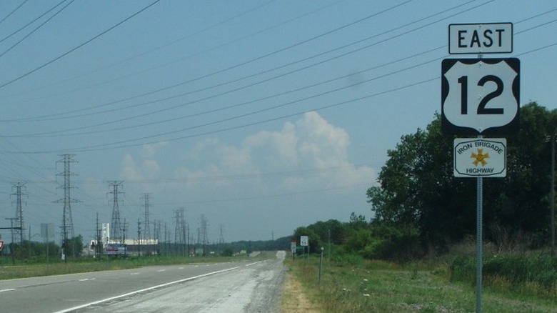
U.S. Route 12 stretches 2,484 miles from Detroit, Michigan to the serene seaside of Aberdeen, Washington. It passes through 10 states: Washington, Idaho, Montana, North Dakota, South Dakota, Minnesota, Wisconsin, Illinois, Indiana, and Michigan, with Montana having the longest stretch of U.S. Route 12, covering almost 600 miles. This Montana stretch is also home to some scenic views of the Rocky Mountains and rolling prairies.
Travelers will appreciate the varying landscapes of this route, from the coastal rainforests of the Pacific Northwest to the rugged mountains of Idaho and Montana. Near the Idaho border, U.S. Route 12 passes through the steep terrain of the Lolo Pass and reaches an elevation of 5,233 feet. However, its highest point is when passing through the Continental Divide at MacDonald Pass, where Route 12 reaches a peak height of 6,312 feet. A stretch of the U.S. Route 12 between Wisconsin, Illinois, Indiana, and Michigan is known as the "Iron Brigade Memorial Highway," honoring the Civil War Union Army unit.
Interstate 10 (2,460 miles)
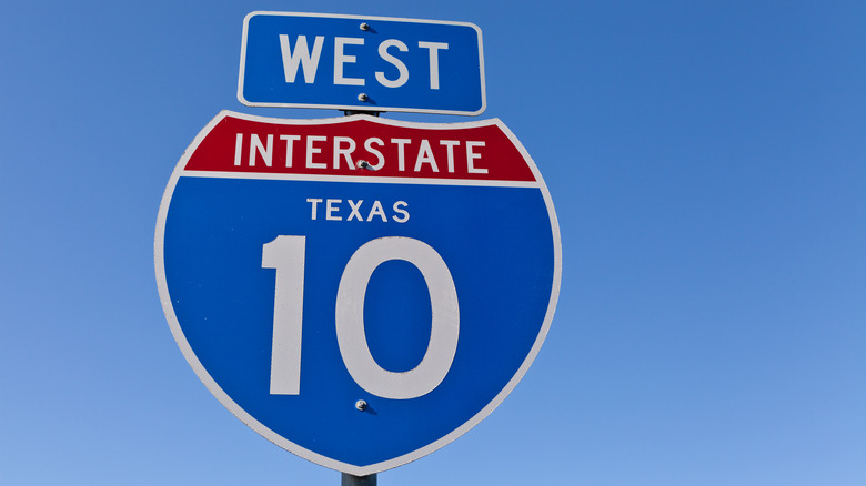
Interstate 10 (I-10) spans 2,460 miles from Santa Monica, California to Jacksonville, Florida. It is the southernmost transcontinental highway in the U.S. The I-10 crosses through eight states, including California, Arizona, New Mexico, Texas, Louisiana, Mississippi, Alabama, and Florida, with Texas having the longest stretch, covering approximately 879 miles — nearly one-third of the highway's total length.
Interstate 10 is also considered one of the most traveled highways in the U.S. Drivers will also be glad to know that I-10 is the longest freeway in North America with no tolls. However, this convenience contributes to its reputation as one of the most dangerous highways in the country. Other reasons include a large volume of commercial trucks, constant road construction, and many distracted drivers. Travelers should be mindful of fuel stops, as there is a gap of 70 miles in Texas with no fuel stations.
U.S. Route 66 (2,448 miles)
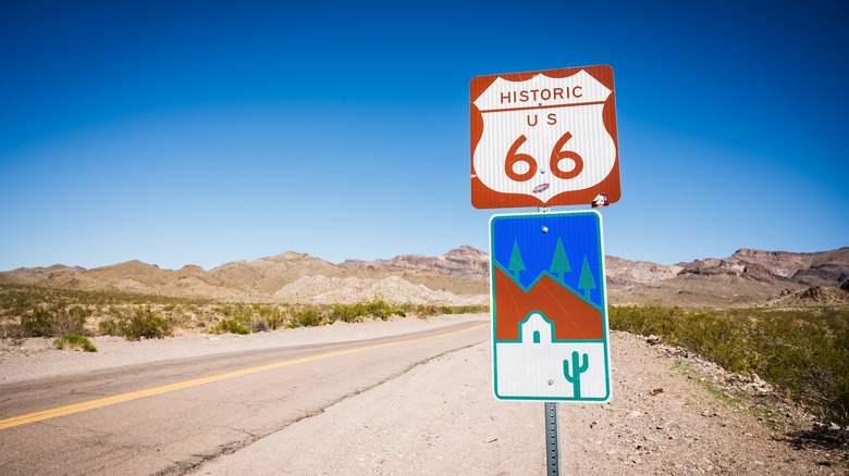
Although U.S. Route 66 is not the longest highway in America, it surely was and is one of the most iconic highways in the world. Originally stretching from Chicago, Illinois to Santa Monica, California for 2,440 miles, it passed through eight states: Illinois, Missouri, Kansas, Oklahoma, Texas, New Mexico, Arizona, and California. Oklahoma holds the largest portion, with over 400 miles of the route.
The highway took riders through the agricultural fields of Illinois to the hills of Missouri, the open ranches of Texas, and the iconic truck stops of the southwest before reaching the sprawl of Los Angeles. Established in 1926, U.S. Route 66 served as an important route for migrants heading west in search of better opportunities during the Great Depression and the Dust Bowl era.
U.S. Route 66 was popularly known as "America's Main Street" and the "Mother Road," as it connected several small towns with major cities. However, the creation of the Interstate Highway System resulted in its decommissioning. In 2008, the World Monuments Fund placed Route 66 on the Watch List of 100 Most Endangered Sites. Efforts are underway to revitalize Route 66 with shops, restaurants, and other tourist businesses. According to David Dunaway, chairman of the Road Ahead Partnership, "The road isn't dead, it just keeps changing."