The Incredible History Of The Lake Pontchartrain Causeway - USA's Longest Bridge
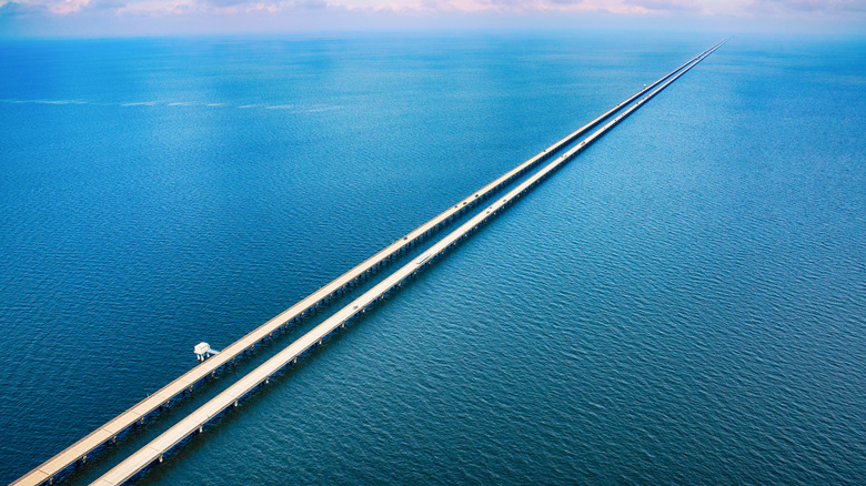
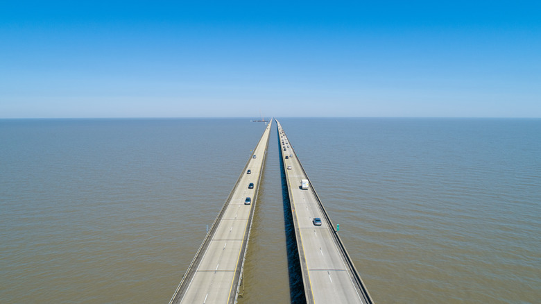
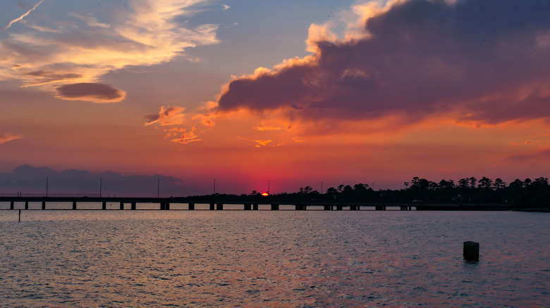
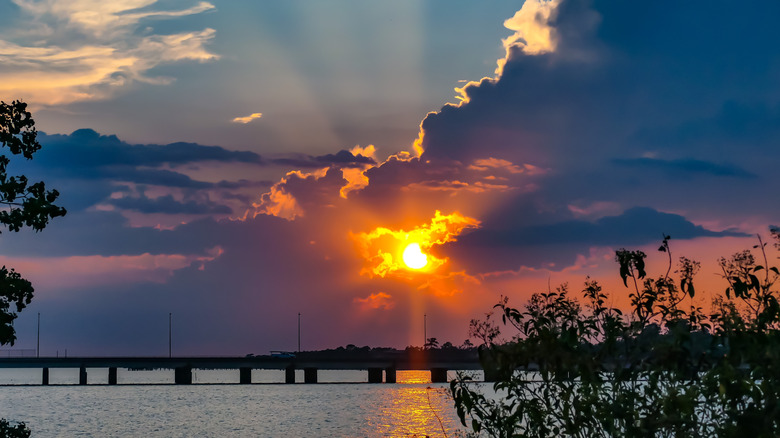
Imagine setting off at sunrise to drive across a bridge. For mile after mile, it runs low over calm waters until you realize something amazing: you can no longer see land. Pelicans soar overhead, and suddenly your passenger gasps at the sight of dolphins leaping from the water; you wish you weren't the one driving so you could watch. When you go over low rises that allow boats to pass under the bridge, you can see both spans stretching far into the distance. By the time you reach the other end, 24 miles and almost half-an-hour later, the blush of dawn has given way to the blue skies of a bright, Louisiana morning.
This incredible bridge is called the Lake Pontchartrain Causeway, and its history matches the growth of twentieth-century New Orleans. It has become an icon of the region while holding the Guinness World Record for the longest bridge that runs continuously over water anywhere on Earth. For decades it was the world's longest bridge. When its original two-lane span opened on Aug. 30, 1956, it was a marvel of engineering that utilized innovative bridge construction techniques. The Causeway's success led to a second, parallel span opening in 1969.
Not every drive across the Causeway goes as smoothly as imagined above, and the bridge isn't without challenges. With 30,000 cars crossing the bridge every day — an astounding 11 million per year — there have been inevitable growing pains. The Causeway's spans have needed to be modified to handle the challenges. It's all part and parcel of being one of the most important roadways leading to the city of New Orleans.
The Geography of Lake Pontchartrain
Lake Pontchartrain is a shallow, brackish, tidal lagoon that's 40 miles long and 24 miles wide between the northern suburbs of New Orleans and several parishes, including St. Tammany at the Causeway's northern end. Brackish means slightly salty, as in estuaries where freshwater rivers meet with tidal waters from the ocean. Lake Pontchartrain sees fresh water from several lakes and rivers along with salt water from the Gulf of Mexico. It occasionally gets overflow from the Mississippi River when its waters spill over.
The result is a dynamic and complex environment, which supports many birds, including bald eagles and ospreys. Huge flocks of purple martins roost under the bridge throughout the year, drawing throngs of bird watchers. Sharks and dolphins are also spotted from time to time. Other aquatic mammals include manatees and otters. And of course, this being Louisiana, there are alligators. Bald cypress trees used to flourish around the lake shores, with their exposed roots sometimes growing into the lake's waters. However, changing salinity has reduced their numbers.
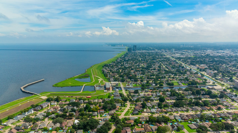
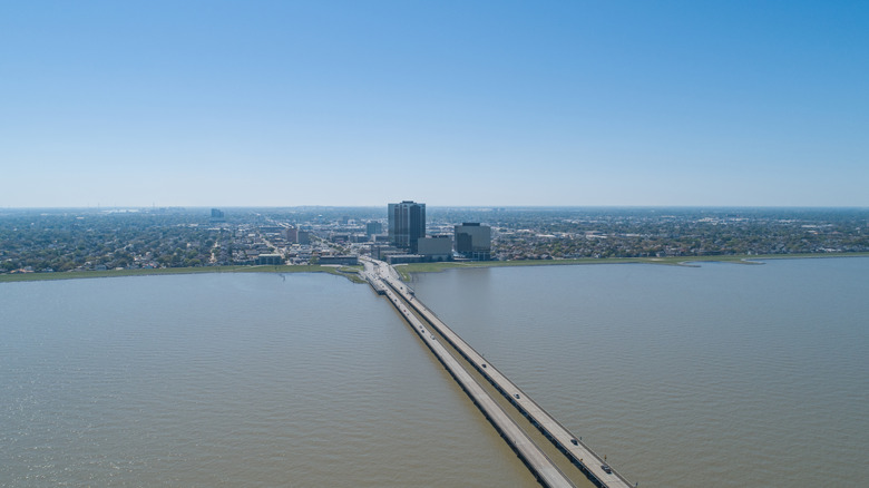
New Orleans lies along the southern shore of the U.S. Its western suburb of Metairie anchors the southern end of the Causeway. Resorts dot the lake shores, along with ports and harbors, including artificial harbors like Port Pontchartrain.
Why was the Causeway Built?
Human settlement around the lake led to transportation issues. The New Orleans area flourished, and pumps made it possible to develop land that had previously been inundated. As a result, the region grew rapidly through the twentieth century and became a major tourist attraction in the post-World War II era. Travelers were drawn to the unique culture of the area and festivals like Mardi Gras.
The area's growth drove traffic between New Orleans and the North Shore, but the lake was a major impediment. Crossing it by ferry or driving around it on the roads of the day could take hours. People living north of the lake were cut off from work opportunities in New Orleans. People from the city had to drive hours to reach the resorts on the North Shore of the lake. It became clear that a solution was needed.
The Greater New Orleans Expressway Commission (GNOEC) was formed to explore bridge options. This commission is often called the Causeway Commission and still maintains the bridge and collects tolls today. The architecture firm of Palmer and Baker won the contract to design the bridge. Since bridges built over water offer unique challenges, a joint venture called the Louisiana Bridge Company, was formed from Brown and Root, Inc., and T.L. James Company.
Building the First Span
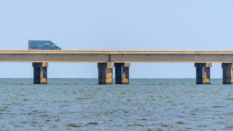
The contract for the bridge called for it to be completed in 23 months, and the soil beneath Lake Pontchartrain offered unique challenges for construction, so innovative bridge-building techniques were brought to bear. These methods became known as "Accelerated Bridge Construction." The Causeway's first span used techniques created by Dr. Maxwell Upson of the Raymond Concrete Pile Company. Upson developed 54-inch hollow cylindrical prestressed concrete piles, which replaced the 24-inch solid piles used in most bridges. These piles were manufactured in a process that used centrifugal force to dry them faster and create concrete that can support 10,000 pounds per square inch.
The bridge's design was intentionally simple and repetitive. This modular technique was essentially a form of mass-production bridge building. Identical components were prefabricated in a concrete casting plant at the northern end of the bridge and then transported by barge to be installed into the bridge. This assembly-line approach proved highly efficient, requiring just fourteen months to complete.
Today this original bridge is the southbound span of what is now a twin-span Causeway. It stretches 23.83 miles and consists of 2,246 individual spans or decks of approximately 56 feet in length and 28 feet in width. Each span is 10 feet above the average water level of the lake, except for four rises and a drawbridge to allow lake traffic to pass underneath. Three of the rises provide 25 feet of clearance for vessels while one rise offers 50 feet of clearance. The drawbridge is eight miles from the northern shore and 16 miles from the southern shore and requires vessel operators to schedule openings at least three hours in advance. The drawbridge will not open during high-traffic periods on the Causeway.
Building the Second Span
As impressive as the first span of the Causeway was in both its length and construction techniques, it offered only two lanes for traffic: one northbound and one southbound. It was an immediate success, opening up travel and commerce between New Orleans and the North Shore. It expanded the New Orleans metropolitan area by making it possible for residents of the North Shore to commute into the city.
However, this quickly revealed the limitations of the Causeway as originally built. By the 1960s, it became clear that another span was needed. This would allow the original span to become the southbound bridge, while the new span would carry northbound traffic. Construction began in 1967, with the new span designed by the firm of David Volkert & Associates. A joint construction company was formed that included the former Raymond Concrete Pile Company. Construction closely resembled the prefabrication method used in the first span, but each new deck was 84-feet-long compared to the first span's 54-foot sections, and they were five feet wider at 33 feet.
The new bridge was also 50 feet longer in total, making it 23.83 miles in length. At this point, the Guinness Book of World Records recognized it as the world's longest bridge, a record which was undisputed until 2011 when China's 26.5-mile Jiaozhou Bay Bridge opened. However, the Causeway's defenders argued that it should retain the title because it runs entirely over water, whereas the Jiaozhou Bay bridge includes land bridges and a tunnel. To resolve this, the Guinness Book created a new category called "the longest bridge over water (continuous)," a record that the Causeway holds to this day.
The Effect of the Causeway
To comprehend how the Causeway transformed travel in the region, you can look at how much time it saves drivers. Using one of the most popular Android Auto maps, driving from Metairie (the suburb immediately to the west of New Orleans where the southern end of the Causeway is anchored) to Mandeville on the North Shore takes 30-45 minutes in the evening rush hour. Traveling between those destinations around the west side of the lake via Interstate 10, Interstate 55, and Interstate 12 at that time of day typically takes between an hour and 20 minutes to an hour and a half. Traveling through New Orleans and around the lake to the east takes nearly as long.
Before the construction of the Interstate Highway system, the Causeway would have offered even greater time savings. It made commuting between the North Shore and New Orleans much more feasible. Mandeville and other towns have thrived because of this direct connection to the Big Easy. Not only does it offer North Shore residents access to jobs in the city, but commerce flows the other way, too. Stores and restaurants north of the lake have flourished as tourists from New Orleans have an easier time getting to them. Plus, the bridge offers travelers from the north easy access to New Orleans tourist attractions like the French Quarter, the Louisiana Superdome, or the National World War II Museum where you can ride one of the last remaining Elco PT boats on Lake Pontchartrain.
What It's Like to Drive on the Causeway
The Causeway has become a tourist attraction in its own right as drivers seek out the novelty of driving for 24 miles over lake waters. If you plan a drive across the lake, keep a few factors in mind. For one thing, there is a $6 toll for southbound drivers, although there is no northbound toll. Plus, the Causeway experiences heavier traffic at certain times of day such as morning and evening rush hours, when the crossing can take 45 minutes or more. Using Waze or Google Maps on Android Auto or using Apple Maps to compare routes can help you determine the best time of day to travel.
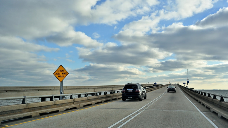
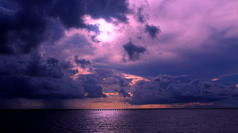
Weather is another factor to consider. Being over open water, the bridge is subject to high winds, fog, and other driving hazards. Keep this in mind when planning your trip; there are excellent weather apps for Android phones and both free and paid apps for iPhone to help you plan. The Causeway itself has 19 message boards along its length to alert drivers to weather hazards as well as traffic slowdowns or accidents ahead.
Once you're underway, you're in for an unforgettable driving experience. The blue waters of the lake roll by on either side of you while clouds scud across the sky from one wide-open horizon to the next. Birds frequently soar overhead. On windy days the lake waters can get choppy. The effect of the drive has been described as mesmerizing. But don't worry: if you get overwhelmed, there are six pullouts called safety bays on each span of the bridge approximately four miles apart from each other, so you're always within a few minutes of a spot for an emergency pull-over.
Safety Issues
As mentioned earlier, the Causeway's long traverse over water leads to unique conditions seen on few other bridges. While many drivers find the crossing relaxing and hypnotic, there is an eight-mile stretch in the middle of the lake where drivers are completely out of sight of land. This area can be particularly disorienting, as people feel like they're driving in the middle of the ocean. Some panic and freeze up, even stopping their cars in traffic. Members of the bridge's 20-person police force often need to drive out to rescue people in this situation. There's even a psychologist who specializes in helping people to get over their fear of the bridge. Plus, the Causeway's sheer length leads to unexpected events, including babies born mid-way when their mothers didn't make it to the hospitals.
Accidents can cause severe traffic backups since there are no detours once you're underway. (There are seven crossovers between the two spans, but under normal conditions, those are intended only for emergency vehicles.) One major cause of accidents is fog; for instance, on a December day in 2024, a series of fog-related crashes on the Causeway involved more than 40 vehicles and caused more than 30 injuries. So if the electronic message boards along the spans warn you of foggy conditions, take them very seriously.
Concerns about crosswinds have led to a motorcycle ban on the Causeway in the past, and high wind warnings can still lead to motorcycles being prohibited along with other vulnerable vehicles like RVs. All vehicles can be banned from using the Causeway during extreme weather events like hurricanes. In January of 2025, the Causeway was even closed for several days following a heavy snowstorm — an extremely rare event for southern Louisiana!
The Future of the Bridge
The Causeway carries far more traffic than its original designers could have predicted when it opened in 1956. GNOEC recognized this, and in 2019 construction started on an upgrade: 12 safety shoulders, with six on each span. Each is up to 1,008 feet long and offers motorists additional space to pull over safely during mechanical or medical emergencies. Many of the Accelerated Bridge Building techniques used in the Causeway's construction were applied to building the safety shoulders.
They will be especially useful in preventing traffic hazards and backups due to breakdowns since the Causeway sees up to a dozen of these per day. With only two lanes and narrow shoulders, even a driver pulling over for a check engine light can cause havoc. The safety bays are one of several new safety features, along with the electronic message boards and new, 46-inch-high guardrails. The latter replaced the old 36-inch-high guardrails, which contributed to a number of fatalities resulting from cars going off the bridge. Adaptive lighting systems have also been installed.
GNOEC is also faced with the challenges of maintaining an aging piece of infrastructure. Time takes its toll, and brackish water and Louisiana's high humidity inflict additional damage over the years. In 1998, a $12 million project upgraded and repaired many components of the bridge. In particular, all 9,000 of the concrete pilings were replaced. These improvements were part of a program of maintenance that continues to this day, intending to maintain the Causeway's reputation as one of the most structurally robust bridges on Earth. Its rugged image was enhanced when it survived Hurricane Katrina with little damage, while the nearby Interstate 10 bridge was heavily damaged and put out of commission for years.