How Often Does Google Maps Update?
Google Maps has become an indispensable part of our lives, with many of us being reliant on it for navigation — be it for discovering new locations, or just picking the best route to commute to work for the day. This platform is available on the web and as an app for Android and iOS, but that's not all. Countless third-party websites and apps depend on the Maps API, without which tasks that require location services would be a nightmare to accomplish.
Beyond basic navigation, there are several other Google Maps features that can change the way you use the app. For example, you can use it to find where you parked your car, or check the busiest commute times for trains, trams, and buses so you can plan ahead for a smoother journey. Then there's the entire exploration aspect of Google Maps, where you can find new restaurants, clubs, or nearby gas pumps in more dire situations — all based on reviews left by real users.
While it's truly impressive how vast the capabilities of Google Maps can stretch, a question that may have popped in your mind is how often the service gets updated — and if you can rely on its directions and recommendations for areas you're unfamiliar with.
Google Maps is being updated constantly
With over a billion active users a month across 220 different countries, Google claims that Maps is being updated by the second. This is largely thanks to the contributions made by other Google Maps users every day — you might have received occasional questions about a place you've visited to as well. User reviews in the form of ratings, comments, and photos play a huge role in the upkeep of exploring places using Google Maps.
Another huge feature of Google Maps is the ability to zoom into a street and view your surroundings in a panoramic view. This is extremely useful to pinpoint addresses and to get familiar with new areas. This mode has been around for quite a while, and has given rise to some of the best Street View photos on Google Maps of all time. Unfortunately, Street View cannot be updated as frequently, as it requires specialized vehicles with 360-degree cameras to scan the place.
Areas that are densely populated and popular are likely to be updated more frequently with new imagery, compared to suburban or rural districts. You can view the dates for the areas that are set to be updated with new Street View images through Google Street View's official tool.
Checking when Street View imagery was last updated
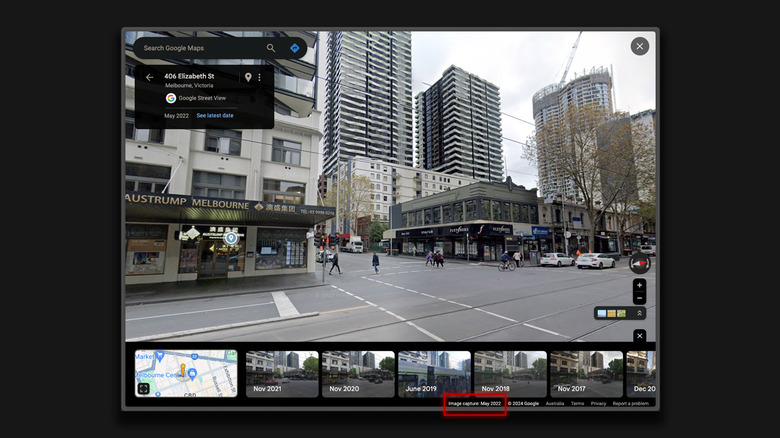
While you cannot request places to be updated with new Street View photos yet, the next best thing would be to check when the existing imagery was captured. This can be useful in determining the accuracy of the Street View images, since an area can look dramatically different if it hasn't been updated in a hot minute on Google Maps. Doing so is easy and can be accomplished by following these steps on a computer:
- Head to Google Maps and zoom into a street of your choice.
- Click and drag the Street View pin from the bottom-right corner.
- Drop it on the desired street, and you should enter the 360-degree Street View.
- In the bottom-right corner of the map, you can view the month and the year the image was captured.
You can find the same information on the Google Maps app on your phone, too. When reading customer reviews, keep an eye on the date of posting — this may be another good way to form expectations of the places you plan on visiting to. There's even a way to time travel with Street View on Google Maps, essentially allowing you to view the same street throughout different years.


