5 Technologies That Changed Exploration Forever

Since the earliest humans set out to pursue herd animals for sustenance, exploration has been humanity's prerogative. Even after the advent of grain production and animal domestication, explorers continued to seek what was beyond the horizon. As people migrated and developed complex economic and political systems, finding an accurate route to a destination became a matter not just of survival but victory in warfare and billions of dollars of economic activity.
Humanity has developed several technologies, both rudimentary and advanced, to determine its position on the globe. The most challenging type of navigation applies to oceangoing travelers. With no roads or landmarks on a planet that is mostly water, the ability to navigate the seas was integral to the formation of human civilization and its complex national systems. From the earliest tools to search for what's over the horizon to the latest space-age gadgets, here are a few technologies that changed exploration forever.
Traverse Board
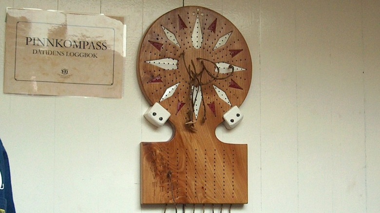
The traverse board resembles a Chinese checkerboard and emerged among northern European and Scandinavian mariners during the 15th century. These navigational tools were crucial in helping sailors accurately record a ship's course of travel using a system known as dead reckoning. This method requires three bits of information: compass heading, speed, and time spent on each heading. It was a vital part of a sailor's toolkit. To measure a ship's speed, they would drag a piece of wood, known as a log, behind the vessel. A rope with evenly spaced knots would unfurl from the log, and the number of nodes that played out in a specific amount of time was recorded as the ship's speed, giving us the nautical unit of speed known as knots.
The practical application of the traverse board was a significant advancement in maritime history. It allowed more specific notations of a ship's course and speed. Each circular traverse board had several pegs attached to strings and a series of holes marking along 32 compass points. During each watch — a period of four hours on a ship — sailors would insert a peg into the hole corresponding to the vessel's course. They did this every half-hour, as measured by an hourglass. Some later traverse boards had additional attachments along the bottom to record speed.
At the end of each watch, the ship's master meticulously recorded the information from the traverse board in a log book, thereby creating a detailed navigational record of the voyage. The precision provided by the tools was instrumental in helping many sailors reach their destination safely and in good time.
[Featured image by Anneli Salo via Wikimedia Commons | Cropped and scaled | CC BY-SA 3.0]
Caravel
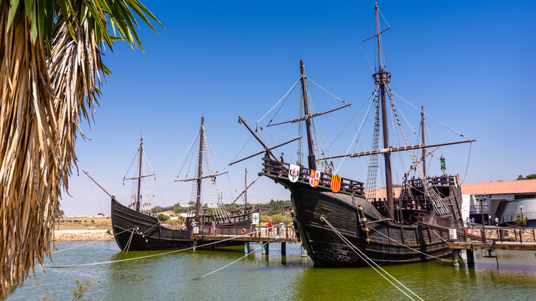
Before the industrial age, exploring the earth's oceans required the cooperation of wind and tide. Square-rigged sailing ships cruised with the wind, meaning it essentially had to be blowing in the direction of desired travel for a successful voyage. Sailors and explorers of the time studied the routes and direction of the air current to determine when a trip would be most beneficial.
Arab trading ships in the eastern Mediterranean developed a type of sail known as a lateen. It provided one enormous advantage: It could tack against a headwind or travel against the air current. The Portuguese, a great maritime nation during the Age of Exploration, adapted this technology to a revolutionary ship called Caravel. These were small, maneuverable, and lightly-manned exploration vessels with triangular lateen sails. The reduced crew meant supplies lasted longer during a voyage — a critical consideration at a time when scurvy and malnutrition reportedly killed more sailors than storms and naval attacks.
The lateen sail was attached to a crossbar on the mast, with its loose rear-angle attached to the stern by a rope. This allowed the ship to catch the wind on the port or starboard side and tack in a zigzag pattern against the air current. Caravals were also compact and light and required only a small crew, which required fewer victuals. The Portuguese put the Caravel to great use, exploring the coast of Africa, rounding the Cape of Good Hope, opening a sea route to India, and accessing its lucrative spice trade, bolstering their empire as a maritime superpower.
Magnetic Compass
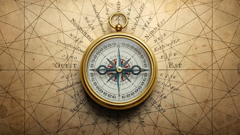
Simultaneous use of magnetic compasses for navigation first occurred in Europe and China around the 12th century. The first known compass appeared in the 4th century B.C., though not as a navigational device. Chinese fortune tellers used a natural magnetic ore known as a lodestone to align the environment into an optimal layout, a Toaist practice known as Feng Shui.
Mariners noticed that the lodestone floated on a piece of wood, setting itself north-south. The earth itself is essentially a magnet, with magnetic poles in the north and south, so the magnetized stone aligned itself with the poles. Rubbing a piece of steel or iron against the lodestone would also temporarily magnetize the metal.
The earliest magnetic compasses in ships were bowls of water with a floating lodestone within. As the ship changed course, the ore continued to point north, allowing sailors to extrapolate their relative direction. Initially, these tools only marked north and south, but soon, explorers developed 32 individual points around the compass's border to further delineate direction. Ultimately, 360 individual degrees allowed for more accurate readings.
The addition of a compass to a traveler's toolkit whether at sea or on land, made it possible to determine direction irrespective of whether the stars or landmarks were visible. A ship could now navigate out of sight of land with a reasonable expectation of making it back. This paved the way for Chinese mariners to explore as far away as Africa and Australia and European explorers to sail beyond horizons. Today, wayward travelers have easy access to compass apps for their smartphones.
Sextant
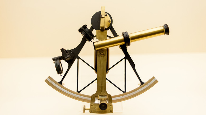
Celestial navigation was the primary means of determining direction and location before the adoption of technologies like compasses and radio navigation. Astronomers studied the path and position of heavenly bodies, predicting future positions hour by hour, years into the future. They collected the data and published them in books known as almanacs. Navigators carried these listings to inform them of the proper position of a celestial body on any given day and time.
Navigators needed a precise measurement of the angle between the horizon and an astral body. Coupled with a precise chronometer and a sight reduction table with published values, the information provided the latitude of the sextant's user, accurate to a few hundred meters. The device looks like a mathematical compass, with a telescope mounted to a rigid frame. Scientists and scholars used tools similar to sextants — such as an astrolabe — to measure the angles of stars above the horizon. Still, the sextant began life as a navigational instrument during the 16th century. Viewing a celestial body through its telescope indicated its angle above the horizon for comparison with the sight reduction tables, giving sailors a relatively accurate representation of how far above or below the equator they were sailing. If you want to try some celestial navigation of your own, Harbor Freight can sell you a sextant of your very own.
Global Positioning System

Almost every item on this list has been rendered obsolete by a groundbreaking new technology. The story of global positioning satellites began when the United States Navy needed a method to track its submarines. The Armed Forces branch conducted experiments in the 1960s, a time marked by the space race, and found that tracking a satellite was possible by following its shifting radio signals. The U.S. government soon adopted this method to help nuclear submarines pinpoint their exact location.
Recognizing the potential of a fully formed Global Positioning System (GPS), the Department of Defense (DOD) built on the Navy's work to launch a series of satellites with this specific mission. Between 1978 and 1993, 24 devices were introduced into orbit, culminating in creating a fully operational system in 1993. The current system relies on 31 GPS satellites working in concert with a wide range of ground stations to provide precise location information to anyone with access to the system. Though the DOD operates the network, the benefits of GPS are available to anyone in the world with a smartphone or dedicated global positioning unit.
The GPS has separate levels of access. The Standard Positioning Service is available to anyone who wishes to use it free of charge. Meanwhile, the Precise Positioning Service is accessible only to the U.S. military, its federal agencies, and its allies. NASA even uses GPS to protect exotic wildlife, and DARPA is currently developing an underwater positioning system for ocean exploration. Gone are the days of the astrolabe and dead reckoning that would see travelers safely home. With the proper devices, millions of people can access crucial navigational information.