11 Must-Know Apple Maps Features For Daily Commuters
While smartphones have many advantages and have brought many technologies to the mainstream, one of the best things they do is make navigating much easier. Whether you prefer Apple Maps or Google Maps, you can now use either one to plan every element of your journey, making your daily commute to and from work a breeze. Anyone who has an iPhone has Apple Maps, a navigation system and digital mapping service that fits in the palm of your hand.
These types of apps have revolutionized the way we get around and made things like TomToms and paper maps obsolete due to their sheer convenience and effectiveness. You simply have to type in your location, and your iPhone will instantly find the quickest route. However, Apple Maps has a lot more features than people might know about. Many of these features can help transform your daily commute and ensure your iPhone 15 stays just as useful as we found in our review.
Find your way around a mall or airport
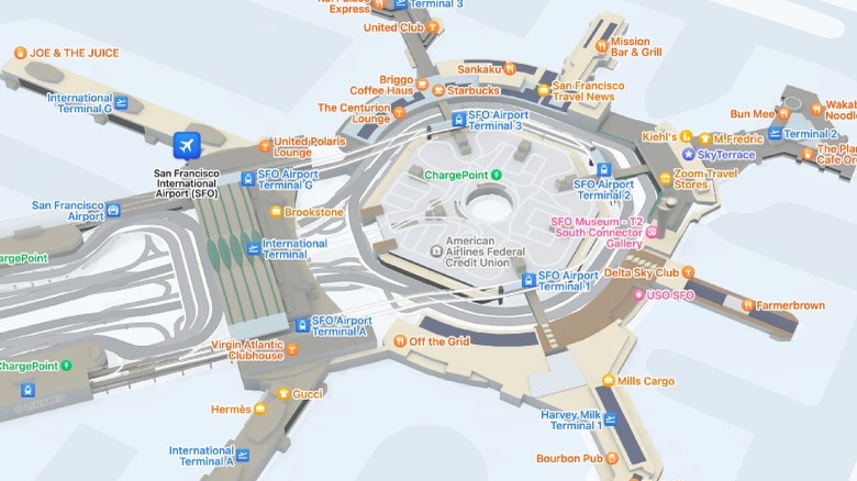
If you want to get around a city in a car or get directions so you can walk to your favorite restaurant, Apple Maps has you covered. But these are not the only situations where you are likely to need some navigational help. After all, how many times have you been in a shopping mall or airport and not had any idea about where you have to go?
While most satellite navigation platforms only work when you are outside, Apple Maps has a feature that allows users to get detailed information about where they are and where they are going when inside certain locations. To activate this feature, you can either zoom in on a building and click Inside Map or use the same button when searching for the location. Once you are in the inside view, you can search for specific locations like a store, restroom, or airport gate. Users can switch to different levels if an area has multiple floors and tell Apple Maps to display only certain types of locations.
Find your parked car automatically
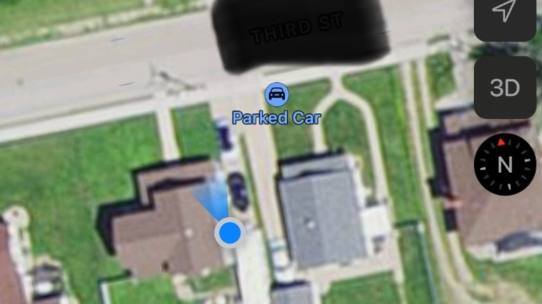
We have all been in a situation where we have parked the car and gone somewhere, only to realize we can't quite remember where we left it. Those who use an iPhone that supports iOS 10 or later won't have to include frantically searching the parking lot on their journey home, as long as they connect the smartphone to their car using either CarPlay or Bluetooth. If you do that, Apple Maps can automatically remember where it is parked so it can be easily found.
This feature needs Location Services turned on and requires Significant Locations to be activated before it will work. From there, simply open the Settings tab in Maps and switch the Show Parked Location toggle to the on position. After that, Apple Maps will drop a pin on the location where you park so you can quickly see the exact location. By selecting Parked Car in the app, you can also get directions straight to the car, so you know what route to take to get back to your vehicle.
Add multiple stops to your journey
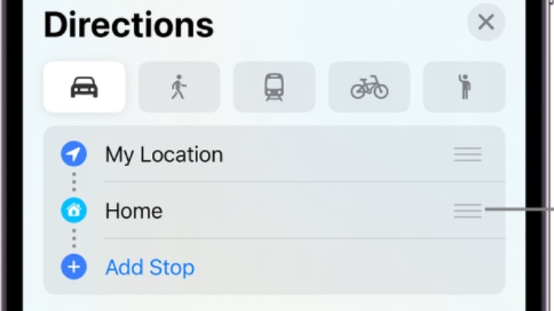
Very few journeys involve going directly to one place and then returning home. If you are going out of the house, you'll probably be visiting multiple locations along the way. There's a good chance that many of these areas won't even be that close together either and it might be difficult to navigate between them. Many people simply set their satellite navigation system for the first place they want to visit and then update it each time they reach their destination.
With Apple Maps, you don't have to keep restarting the journey; instead, you can program several stops. This means once you've reached a destination, it will automatically bring up the directions for the next location you are going to. That makes it far easier to plan ahead and see how long your entire journey will take. Of course, it also has the added benefit of being much more efficient, so you can set everything up before you start, and not have to worry about messing with your iPhone or console while out and about.
Get detailed information about public transport
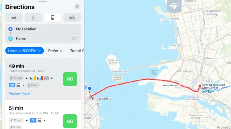
While the iPhone and Apple Maps tie into many Apple CarPlay features, they're just as useful when you are on foot. What many pedestrian Apple Maps users may not realize, though, is that the software has a lot of interesting features to make using public transport a whole lot easier.
As you might expect, Apple Maps can give you directions to train stations or bus stops. However, it goes even further than that, allowing you to plan entire routes using public transport. All you have to do is type in your destination and then choose the Public Transit option. Once that's done, you can choose a route that best suits your needs by choosing whether you want to take the bus, train, tram, or any other available choices.
To make your journey even easier, Apple Maps provides detailed information such as departure and arrival times as well as connection information. So if you are in a major city like London or New York and looking to get a bus, it will let you know exactly where to go and what number to use. It can also provide fare amounts and tell you if you need to swap to a different mode of transport at any time.
Avoid highways and tolls
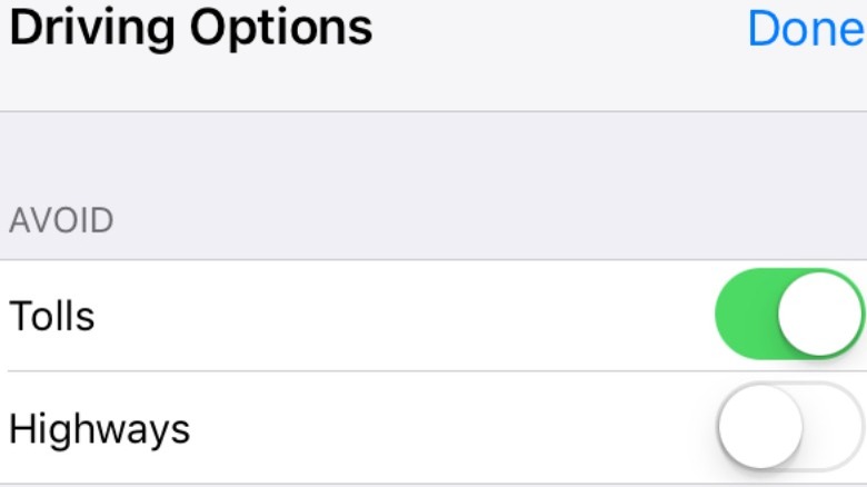
Sometimes, you don't just want to necessarily follow the fastest route when navigating to your destination. Perhaps you know that a certain direction will have heavy traffic that Apple Maps has not accounted for, or maybe you just prefer to avoid particular types of roads. There's also the possibility that the quickest way to get to a location might involve going through tolls, something that many people prefer to avoid so they don't have to pay to get to where they are going.
If that's the case for you, then Apple Maps has you covered. To make sure that Apple Maps doesn't take you on a journey that doesn't involve a highway or a toll, you can select an option when choosing your route immediately after inputting your destination. Right below the Directions list there will be several options that you can select. Under the Avoid tab, users can decide what type of roads they want to avoid traveling on. After that, Apple Maps should calculate a new journey for you that takes these parameters into account.
Make and view restaurant reservations
Apple Maps is not only useful for planning journeys or traveling to destinations. It's evolved to be far more than simple mapping services and now often includes additional services to make your life easier. These kinds of features vary between different apps and Apple Maps has a handy ability to book a restaurant reservation directly through the interface without having to navigate to a third-party site or app.
Apple has developed APIs so that developers can add this type of functionality into Apple Maps for their businesses. Essentially, it works by using tools that send information between Apple Maps and outside extensions that transfer user data to complete the booking. Restaurants and other facilities can do this by becoming part of Apple Business Connect, which gives businesses the opportunity to take over control of their Apple Maps card, allowing functions such as user bookings. Users who use this function will also be able to see all of their own reservations and modify them.
Drop pins to mark and share locations
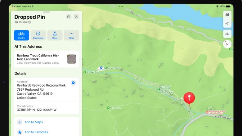
Sometimes locations that you are visiting don't have information on Apple Maps. Maybe you are going to a field or park that doesn't have a name, or you are visiting a new location that hasn't updated its details yet. There's even a chance you are going to a private residence that isn't particularly easy to find with a standard address. In these situations, you can use Apple Maps to drop and share pins, which can be incredibly helpful for finding a location and getting directions.
Once you've dropped a pin, you can edit its name, move it around, or add other helpful information. You can share pins with other users, allowing you to precisely guide them to specific areas. These pins can then be found in the My Guides section in Apple Maps, so you can quickly see and edit them without being near the location.
Find stores and services on your route
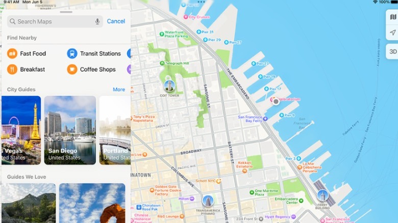
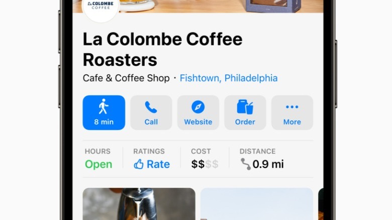
Your daily commute to work will usually involve taking the same route and stopping off at the same places along the journey. However, there are some instances when you might need to take a detour to pick up something on the way to work or drop in for some food as you head home. But how do you know what is along your route other than simply relying on seeing what turns up on the side of the road as you drive by? With Apple Maps, it is possible to find a wide array of different stores and services as you travel.
This can easily be achieved simply by telling Siri to find a type of location near you, such as an Italian restaurant or a gas station. Apple Maps will then give you a list of nearby options and give you directions to the one you select. You can reach the same result by typing the information into Apple Maps or selecting specific categories from the drop-down menu in the app. Details such as opening times, prices, and reviews are also often available to give you a better idea of what establishments suit your needs best.
Navigate using a detailed 3D street view
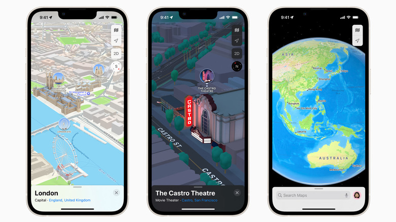
When Apple launched iOS 15 for iPhone and other devices, Apple Maps got an overhaul that introduced a 3D street view, which included far more detail than a traditional map service. While it only works in a select few cities, the selection includes some of the busiest and most populated in the world — places like London, New York, and San Francisco. Anyone who regularly commutes in these cities now has access to this view in Apple Maps, which should make finding locations easier than ever before.
That's because it includes far more information than Apple Maps and its rivals usually do, including details about elevation, building shape and size, as well as the exact layout of roads and streets. It also provides data on bus and taxi lanes, so you know what to avoid. When walking, you can also take a photograph of a landmark or building and your can iPhone scan the image and tell you exactly where you are. This new and improved view even makes it more convenient to cycle to work, by telling you if there are stairs on your route and making them clear to see so you can avoid them.
Share your estimated time of arrival
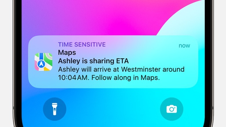
We all know someone who is never on time and can't provide a reliable update on when they will arrive. They might say that they are 10 minutes away, but half an hour later they still haven't turned up. While this might not always necessarily be the fault of the individual you are meeting, it can still be incredibly frustrating. Yet, the same can be true if you are meeting someone and not sure exactly how long the journey will take, especially if you are taking a route you don't know well.
Anyone who has used any sort of digital map service will probably be aware that they usually provide a predicted time of when you'll arrive. What is less well known, though, is a feature in Apple Maps that allows you to share your estimated time of arrival with contacts. You can either use Siri and ask her to share your ETA or do it directly through the app and then choose whom to send this information to. It will even send regular updates in case of delays and give an indicator in Apple Maps of where you actually are.
Check for weather and traffic problems
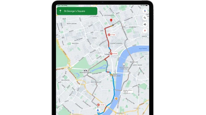
A lot of things can disrupt your daily commute and make traveling less convenient. Among those are traffic and weather problems, two factors that you don't have direct control over. If there's an accident up ahead or adverse weather conditions that start quickly, you could get caught up in traffic jams and significant delays. That could mean being late to work or an important appointment.
Apple Maps can provide a variety of traffic and weather information to help avoid big delays. It will show colored indicators on roads to give you a general idea about congestion while in Driving or Satellite view. Incident markers will also let you know if there are accidents or road closures, with incident reports available to offer more details.
Apple Maps can also offer specific weather information in most regions. These can range from updates about rain and other adverse conditions to information about pollen and pollution levels. The app offers hourly updates for those who want to avoid areas with low air quality or excessive levels of pollen.