10 Apps Every Outdoors Enthusiast Should Have Installed
Some might say that the entire point of exploring the great outdoors is disconnecting from the constant exposure to technology in our everyday lives and connecting with nature. Still, the right technology can be used to enhance this experience and help keep you safe. While you may need to bring along some camping tech to keep you prepared for what's out there, your smartphone can become the perfect outdoor companion if you have the right applications.
Ranging from essential to recreational, these apps are bound to improve your experience. There's something for everyone, whether you're hiking, camping, mountain climbing, biking, or running. With the right apps installed, your phone can transform into a navigation device, automatically send out distress alerts, identify any plant, tree, or mountain in seconds, or turn your camping trip into an outdoor treasure hunt. So, before you embark on your next great adventure, here are 10 apps you should install on your phone.
AllTrails
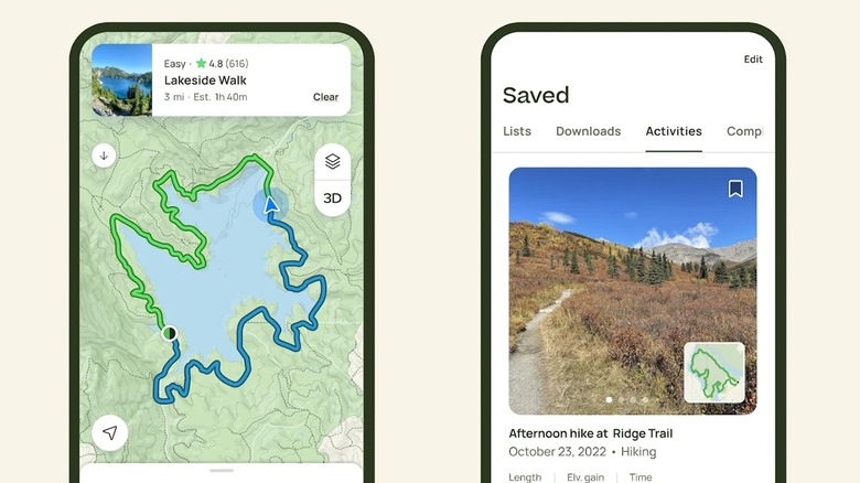
AllTrails is the ideal companion for most outdoor activities, especially hiking and backpacking. Its comprehensive trail guide and easy-to-use navigation system empower its users to explore with confidence and ease. The app supports a wide range of activities with a database of over 400,000 trail maps, with reviews and photos from a community of hikers, mountain bikers, climbers, runners, and other trail-goers.
AllTrails comes with a free and paid version, with the paid version allowing you to download trails and maps costing $35.99 annually. However, depending on your needs, you probably won't need to sign up for the paid version since the free version has a pretty expansive feature set on its own. You can discover new trails from the thousands available on the app created by fellow outdoorsmen, with photos of points along the trail as well as ratings, reviews, and difficulty of the trail. This lets you plan your next trail route to fit your specific needs. It also lets you create custom routes on its website.
With the paid version, you get a handful of extra features, such as Live Share, where designated contacts receive live updates on your location and are notified once you've completed your route. Another safety feature that comes with AllTrails+ is wrong-turn alerts. Here, the app notifies you if you've veered off your set trail. This feature — especially when paired with downloaded maps to use offline in AllTrails+ — will come in handy if you're on a trail with poor service.
Gaia GPS
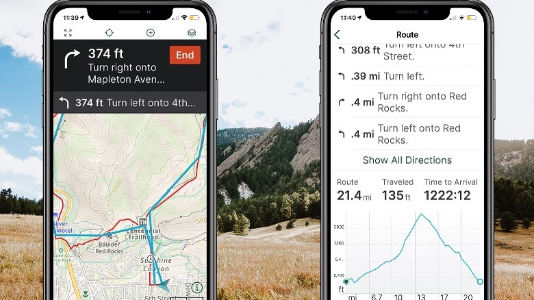
In certain ways, Gaia GPS is pretty much Google Maps for outdoorsmen but taken up a notch. Gaia is great for on-trail and off-trail explorations, with detailed mapping that offers accurate navigation for hiking, camping, and off-road adventures. Gaia GPS is tailored for those with a little more experience outdoors due to its greater functionality and detail.
Gaia operates on a Freemium model, with a free version and two paid versions — Gaia Premium, which costs $59.90 annually, and Outside+ in partnership with the Outside Network, which costs $89.99 per year. Gaia GPS is available on both iOS and Android, but some users have reported a slightly different feature set for the app on either platform.
The Gaia GPS app stands out from other outdoor navigation apps — including AllTrails — thanks to its accurate positioning and incredibly detailed maps. Users can record and save their activities to revisit and review information about their track such as the duration, speed, distance, and elevation. Beyond that, premium members enjoy access to offline maps and over 300 base maps and map overlays that provide extra data such as air quality, wildfires, and snow and precipitation forecasts.
AccuWeather

Knowing what to expect from the weather is vital to any great outdoor adventure. AccuWeather is a veteran when it comes to weather forecasts provided for your phone and is one of the most accurate weather apps out there. It's perfect for casual weather-watching or more detailed meteorological information, especially if you've lost confidence in your phone's default weather app.
Available on both iOS and Android, the AccuWeather app has a unique and intuitive layout and a robust feature set. AccuWeather uses an equation called the RealFeel temperature to predict the weather. Basically, it takes into consideration all elements that could possibly affect the weather to deliver an accurate forecast. Also, with MinuteCast, you can get a minute-by-minute precipitation forecast for the next 4 hours.
The app has a free version and two paid versions. AccuWeather Premium provides an ad-free experience, which costs $1.99 monthly and $12.99 yearly. There's also an AccuWeather Premium+, which has some extra features like real-time weather alerts and costs $3.99 monthly and $24.99 yearly. While the free version is more than enough to plan ahead, it can get flooded with ads, which is its main drawback.
PlantNet
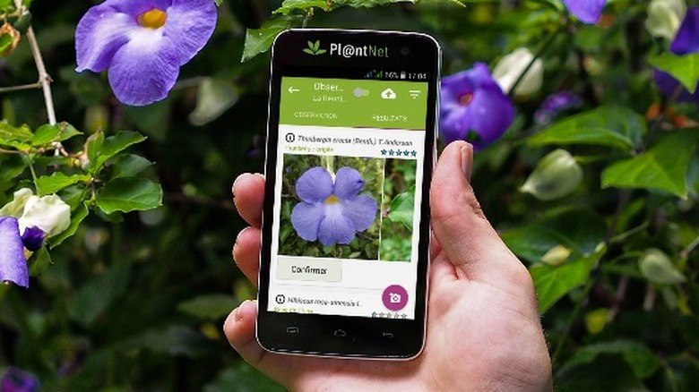
When exploring outdoors, you're bound to come across so many species of plants and flowers that you might want to take note of or maybe research. That's where PlantNet comes in. PlantNet is a free-to-use app that helps users identify plants they come across while exploring. You simply take or upload a picture of the plant you want to identify, and PlantNet compares it to over 50,000 species of flora in its database, giving you a detailed result in seconds.
The app prompts users to provide their location for more accurate results based on the flora typically found in their region. Once you've gotten an accurate identification, you can find details about the plant, like its botanical name and regions where it can be found, as well as links to additional information about it. PlantNet is a handy app to have when outdoors to help you identify potentially allergenic plants like Poison Ivy. It has a simple, easy-to-use interface, perfect for explorers of any skill set, and is available on both iOS and Android.
PeakVisor
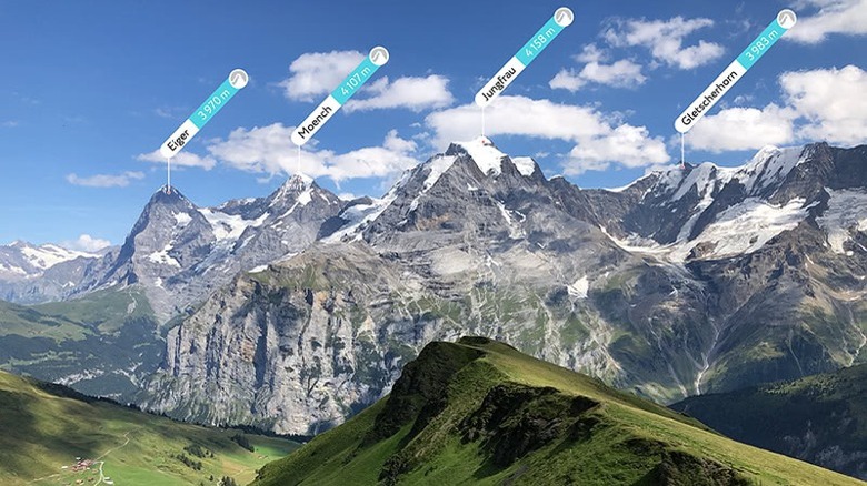
If you're a hiker, mountain climber, or just an admirer of the great outdoors, then PeakVisor is worth checking out. It uses augmented reality to easily identify peaks, mountains, and landmarks around you. All you need to do is point your phone at the skyline and it will show you the names, altitude, and other useful information about any peaks around you, from its database of over a million peaks.
Another useful feature of PeakVisor is its 3D maps that add greater detail to help you visualize the terrain of your next hike or climb. The 3D map also allows you to identify any marked trails or mountain huts in the area. With PeakVisor Pro, you can download the 3D maps so you can use them even when you're in a spot with weak cell service. You can also import hike trails or climbing routes from other sources. While the app is available for free on iOS, PeakVisor requires a $4.99 purchase on Android devices. After downloading the app, users can choose to subscribe to PeakVisor Pro on a monthly basis for $4.99 or sign up for a yearly subscription at $29.99.
Star Walk 2

Whether you're staring out into the night sky while camping or out stargazing with friends, Star Walk 2 is perfect for exploring the wonders of the night sky. It provides real-time information about stars, constellations, planets, and satellites and has an easy-to-use interface. This makes it an ideal companion for not only experienced stargazers but also beginners. With Star Walk 2, you can hold your phone up towards the sky and move it around to see all the stars and constellations out that night.
It uses augmented reality to digitally connect the stars and reveal the constellations in the sky for a more immersive experience. One really cool feature is the ability to look back in time to observe celestial bodies in the night sky at any point in time going back thousands of years. The app also has other activities you can do like reading through the latest astronomy news or taking various fun space-related quizzes. Star Walk 2 has a free version and a paid version that costs a one-time fee of $2.99.
Cairn
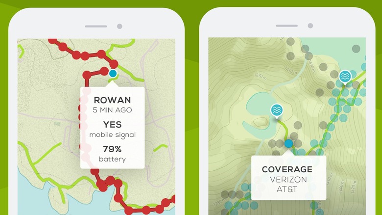
Safety is super important when exploring the outdoors. Apart from staying safe, being able to get help should you need it is also a priority, and it forms the core philosophy of Cairn. The Cairn app offers safety features that guarantee adventurers and their loved ones peace of mind.
Before you set off on your hike, run, or other activity, you're prompted to set up your designated contacts, which the app calls your safety circle. You can then share trip plans with your safety circle, including your route and expected return time. If you're running late — unless you indicate that everything's okay — it automatically alerts your circle and provides them with any important information they may need to help in case there's an emergency. The great thing about this feature is that an alert will be sent out even if you're offline or have weak cell service. Your circle also has access to your live location so they can see where you are at any point.
That's not all though. Cairn also shows you where along your route you're likely to have cell service. It does this by gathering information provided by other users. Also, you can download the map of your route to use offline so you can still navigate in an area with spotty cell service. However, most of these features are only available if you subscribe to Cairn Premium, which costs $4.99 for a monthly subscription and $26.99 for a yearly subscription.
First Aid - IFRC
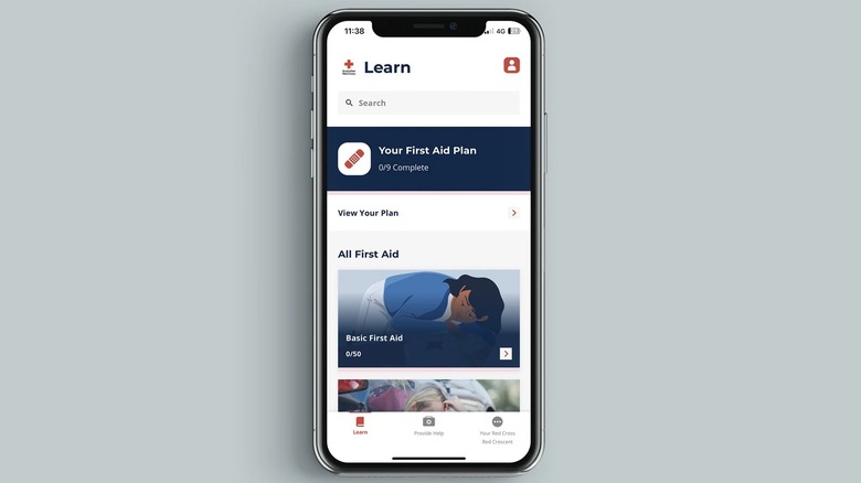
Whether you're hiking, climbing, or camping, having some degree of first aid knowledge is really important in case of bruises, injuries, and other accidents. However, not everyone might have the skill or know-how to administer emergency treatment. The First Aid app, developed by the International Federation of Red Cross and Red Crescent Societies, has instructions and guides for handling the most common first aid emergencies, such as bleeding, burns, fractures, and blisters.
The First Aid – IFRC app provides basic first-aid information and guides on water, road, food safety, psychological first aid, and general preparedness. The app breaks these guides into short lessons for easy navigation and quick access to relevant information. But sometimes, you might find yourself in a situation with no idea what the problem is and where to start. Luckily, the app has a feature where you can answer a series of questions based on your symptoms, and it recommends a guide on what to do.
You can also test your knowledge of what to do in various first-aid emergencies by taking one of the many quizzes on the app. One last feature worth noting is that it allows users to quickly contact first responders based on the emergency phone number of their country or region. It's also pretty handy because it's completely free, making it accessible to everyone.
The Dyrt
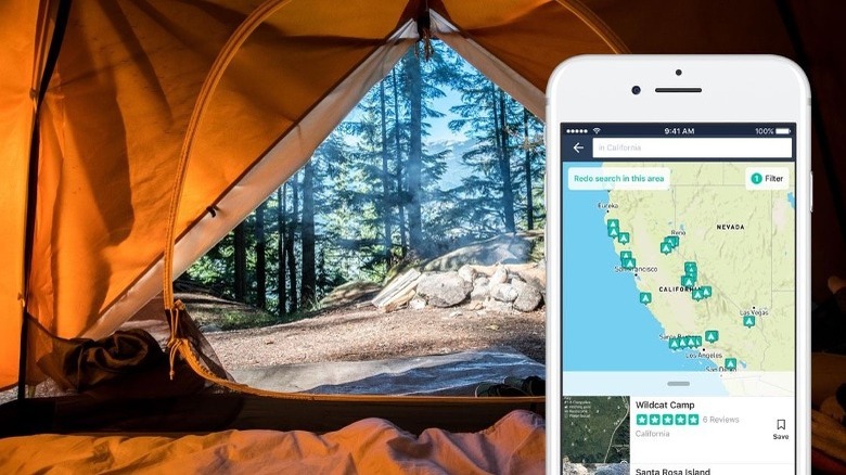
With a community-contributed database of over 500,000 campgrounds across the United States, The Dyrt allows users to easily find campgrounds in their preferred location, as well as detailed information about them, such as whether they're pet-friendly, the amenities available at the campsite, and their contact information. Whether you're glamping, front country camping, or van camping, The Dyrt can help you discover the spot for your next adventure.
The app has a free version with a pretty limited feature set, but you can still discover campgrounds in your area based on the type of camping you'll be doing. Each campground on the app has reviews and photos from other campers who have camped there. You can also bookmark campsites you're interested in for later, which is handy when planning your camping expedition.
With The Dyrt PRO, you can access even more features, like booking campsites directly on the app. Like many apps on this list, a pro membership lets you download maps offline. However, the subscription will cost you $35.99 a year.
Geocaching
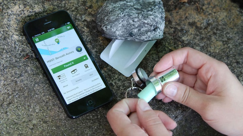
If you're looking for a fun activity to do with your family, and while camping or exploring outdoors, geocaching is the perfect way to use technology to turn your surroundings into a treasure hunt.
Geocaching is a real-world treasure-hunting game that involves using GPS coordinates to find hidden containers called geocaches or caches. The official Geocaching app provides a database of geocaches worldwide, allowing you to discover hidden treasures while you hike or camp. Anyone can set up a geocache and upload the location on the internet. You can then use the app to track and find these hidden treasures.
On the Geocaching app, you can find details about the geocache before you begin your hunt for it, like who placed it, how big it is, how easy it is to find, and how difficult or easy it will be to navigate the terrain where it is hidden. You can also message other members of the geocaching community for helpful tips.
With the premium version of the app — which costs $39.99 yearly and $3.33 monthly — you get access to premium caches, offline geocaches, and the Lists feature that helps you plan geocaching expeditions beforehand.